boathouse, Kerrs Bay Road · NIAH 40819033
boathouse, Kerrs Bay Road · NIAH 40819033 tercatat di Rathmullan, DONEGAL, Irlandia sebagai bangunan transportasi. Rekaman 40819033 memuat uraian arsitektur dan konteks bangunan. Bahasannya mencakup pasangan batu potong (ashlar), pasangan batu tidak beraturan (rubble), batu (stone), bata (brick).
- Jenis objek
- Bangunan
- Fungsi
- bangunan transportasi · penelusuran klasifikasi sumber
- Masa tercatat
- Rentang taksiran masa dalam inventaris: 1870–1880
- Kondisi dan status
- Bangunan terdokumentasi dalam inventaris
Identitas dan tapak
Inventaris menempatkan boathouse, Kerrs Bay Road · NIAH 40819033 di Rathmullan, DONEGAL, Irlandia. Alamat yang dicatat sumber: Kerrs Bay Road. Lingkup tapak dan hubungan dengan bangunan lain mengikuti keterangan sumber; titik tidak mewakili batas persil.
- Nama utama
- boathouse, Kerrs Bay Road · NIAH 40819033
- Lokasi
- Rathmullan, DONEGAL, Irlandia · Bangunan di Irlandia
- Nama lain dalam sumber
- 40819033; NIAH 40819033
- Klasifikasi sumber
- boathouse · nomor 40819033
- Dasar kondisi
- Keterangan mengikuti snapshot sumber 2023-08-24. Tidak tersedia survei kondisi mutakhir oleh Arsitektur; status perlindungan dan rating dibaca sesuai arti pada sumber.
Lihat di Peta Arsitektur ↗
Ruang dan fungsi
Klasifikasi historis sumber menyebut boathouse. Katalog mengelompokkannya sebagai bangunan transportasi untuk penelusuran. Klasifikasi ini tidak menyatakan fungsi operasional, akses kunjungan, atau kondisi pada saat ini.
Membaca arsitektur
Uraian fisik asli disajikan dengan nomor rekaman 40819033. Kosakata yang disebut meliputi pasangan batu potong (ashlar), pasangan batu tidak beraturan (rubble), batu (stone), bata (brick), batu tulis (slate), kayu (timber), besi tempa (wrought iron), batu pasir (sandstone). Daftar istilah ini membantu penelusuran. Susunan ruang, hubungan antarkomponen, dan fasenya perlu dibaca dalam uraian asli.
Deskripsi fisik dalam sumber
Teks dari NIAH Irlandia · bahasa Inggris
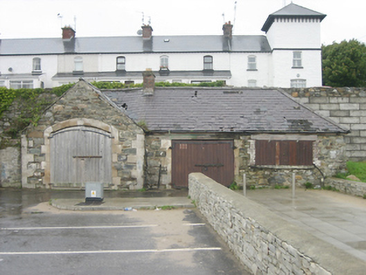
Detached single-bay single-storey boathouse originally associated with the former Rathmullan Coastguard Station (see 40819033) adjacent to the west, built c. 1875, having integral segmental-headed carriage-arch to the front elevation (east), and with attached two-bay single-storey outbuilding attached to the north. Now in use as an outbuilding. Pitched natural slate roof to boathouse and hipped natural slate roof to attached outbuilding to the north; red brick chimneystack to the south end of attached outbuilding. Rubble stone walls to boathouse with raised and dressed block-and-start quoins to the corners of the front elevation. Rubble stone construction to attached outbuilding. Segmental-headed carriage-arch to front elevation of boathouse having dressed sandstone block-and-start surrounds, dressed ashlar sandstone voussoirs, and with replacement battened timber double-doors having wrought-iron hinges. Square-headed window opening to the north end of east elevation of attached outbuilding to the north having red brick block-and-start surrounds, stone sill, timber lintel over, and with modern battened timber shutters. Square-headed carriage-arch to the south end of front elevation of outbuilding having dressed ashlar sandstone block-and-start surround, timber lintel, and with battened timber double-doors with wrought-iron hinges. Set back from road with high rubble stone retaining wall to the rear (west), modern car park to the east adjacent to Kerr's Bay\Lough Swilly, and with section of rubble stone boundary wall adjoining boathouse to the south. Located to the north-east of the centre of Rathmullan.
Pihak dan peran
Perancang dan pelaksana belum diringkas dalam tabel ini. Nama dan perannya mungkin disebut dalam uraian sumber; baca sesuai konteksnya.
Atribusi berlaku pada fase yang disebut. Pemesan, perancang, pelaksana, dan pembangun mempunyai peran berbeda.
Riwayat perubahan
Indeks masa menurut inventaris
Rentang sumber dipertahankan untuk penelusuran masa; riwayat asli menjadi dasar bagi ketidakpastian dan fase lain.
Keterangan tanggal: Batas era DATEFROM/DATETO menurut sumber; bukan durasi pekerjaan, tahun pasti, atau survei kondisi.Uraian fisik dalam inventaris sumber
Identitas dan uraian mengikuti rekaman resmi. Pengambilan data tidak dianggap sebagai survei kondisi fisik mutakhir.
Ukuran dan sistem
Istilah bahan dalam uraian mencakup pasangan batu potong (ashlar), pasangan batu tidak beraturan (rubble), batu (stone), bata (brick), batu tulis (slate), kayu (timber), besi tempa (wrought iron), batu pasir (sandstone). Uraian sumber belum diolah menjadi data ukuran atau spesifikasi teknis. Lingkup komponen dan perubahannya mengikuti uraian asli inventaris.
- Bahan dan sistem
- pasangan batu potong (ashlar) · Kosakata sumber; komponen, fungsi, dan fase mengikuti uraian asli.Dasar informasi:[1]
- Bahan dan sistem
- pasangan batu tidak beraturan (rubble) · Kosakata sumber; komponen, fungsi, dan fase mengikuti uraian asli.Dasar informasi:[1]
- Bahan dan sistem
- batu (stone) · Kosakata sumber; komponen, fungsi, dan fase mengikuti uraian asli.Dasar informasi:[1]
- Bahan dan sistem
- bata (brick) · Kosakata sumber; komponen, fungsi, dan fase mengikuti uraian asli.Dasar informasi:[1]
- Bahan dan sistem
- batu tulis (slate) · Kosakata sumber; komponen, fungsi, dan fase mengikuti uraian asli.Dasar informasi:[1]
- Bahan dan sistem
- kayu (timber) · Kosakata sumber; komponen, fungsi, dan fase mengikuti uraian asli.Dasar informasi:[1]
- Bahan dan sistem
- besi tempa (wrought iron) · Kosakata sumber; komponen, fungsi, dan fase mengikuti uraian asli.Dasar informasi:[1]
- Bahan dan sistem
- batu pasir (sandstone) · Kosakata sumber; komponen, fungsi, dan fase mengikuti uraian asli.Dasar informasi:[1]
Ukuran belum diringkas dalam tabel ini. Baca angka pada uraian sumber bersama definisi, fase, dan lingkupnya.
Dokumentasi dan sumber
Edisi sumber dan hak penggunaan
Copyright Government of Ireland. Data created by National Inventory of Architectural Heritage, Department of Housing, Local Government and Heritage, licensed for re-use under the Creative Commons Attribution 4.0 International licence. Original English Description and Appraisal retained. Indonesian summaries, structured categorisation and selection are adaptations by Arsitektur. No endorsement by the source publisher is implied.
Copyright Government of Ireland. Data created by National Inventory of Architectural Heritage, Department of Housing, Local Government and Heritage, licensed for re-use under the Creative Commons Attribution 4.0 International licence. Original English Description and Appraisal retained. Indonesian summaries, structured categorisation and selection are adaptations by Arsitektur. No endorsement by the source publisher is implied.
Creative Commons Attribution 4.0 ↗
Ringkasan berbahasa Indonesia disusun dari nama, lokasi, kategori, dan istilah arsitektur pada catatan sumber. Teks sumber berbahasa Inggris mengikuti ketentuan penggunaan yang tercantum di atas. Penelaahan ahli independen belum tercatat.
Lingkup identitas: Satu bangunan sesuai nomor inventaris dan uraian pembuka sumber. Bagian yang melekat mengikuti uraian; bangunan terpisah dan kelompok yang tidak jelas disisihkan.
Status sumber: Rekaman inventaris NIAH; pencatatan ini tidak otomatis menyatakan perlindungan hukum RPS · Klasifikasi sumber: Regional. Tanggal penetapan bukan tanggal konstruksi.
Tanggal atau versi data sumber: 2023-08-24.
Survei yang disebut sumber: NIAH Survey of Donegal 2008 - 2012. Ini tidak menyatakan survei kondisi mutakhir oleh Arsitektur.
Penilaian dan konteks dalam inventaris
Teks dari NIAH Irlandia · bahasa Inggris
This well-built former boathouse and attached outbuilding was originally associated with the former Rathmullan Coastguard Station (see 40819006) adjacent to the west. It is well-built using local rubble stone masonry and it survives in relatively good condition, which is testament to the quality of its original construction. The good-quality dressed ashlar sandstone block-and-start quoins to the corners of the boathouse, and to the carriage-arches to the boathouse and outbuilding are of a quality not normally found on utilitarian structures and help to give these structures a robust and vaguely picturesque appearance. Its integrity is enhanced by the retention of the natural slate roofs, which adds a satisfying patina. The associated former coastguard station was originally built in 1875 to designs by Enoch Trevor Owen (c. 1833-81), an English architect working for the Board of Works in Ireland from c. 1860. Owen designed upwards of thirty coastguard stations in Ireland, mainly during the 1860s and early 1870s, including nine in County Donegal. The main contractor involved at Rathmullan was a Matthew McClelland. It is probable that this boathouse was built in junction with this new coastguard station (see below). The present coastguard station replaced and earlier station at Rathmullan, which was extant in 1837 (Ordnance Survey first edition six-inch map); this was located adjacent to the north of the outbuilding. It is possible that this boathouse was originally associated with this former coastguard station where it may have formed the south end of a terrace of structures. The Coastguard Service was established in Ireland (and Britain) in 1822, and its main purposes were controlling smuggling (the evasion of the payment of revenues) and in rescuing seafarers etc. Coastguard stations were built at intervals of ten to twenty miles all along the coastline. The coastguard service later passed into the control of the Admiralty in 1859 who initiated a large-scale programme of coastguard station-building in Ireland, and former coastguard station (and presumably the boathouse) in Rathmullan dates to this period of expansion. The majority of contemporary coastguard station boathouses are now demolished or heavily altered, which makes this building in Rathmullan and increasingly rare example of its type and date. This building forms part of a pair of related structures with the associated former coastguard station, and is an element of the built heritage and maritime history of Rathmullan. It remains an appealing feature along the coastline to the north-east of the town.
- Adaptasi inventaris dengan ringkasan berbahasa Indonesia dan uraian asli berizin. Kurasi data dan pemeriksaan sampel tidak menyatakan penelaahan ahli independen untuk setiap bangunan.
- Nama utama bangunan yang jelas belum tersedia pada bidang nama sumber. Judul katalog menggunakan jenis bangunan dan alamat/tempat beserta nomor inventaris.
- Tanggal akses, survei sumber, penetapan, dan pembangunan mempunyai arti berbeda. Data yang belum jelas dipertahankan tanpa mengisi pihak atau ukuran dengan perkiraan.
Dasar informasi
- National Inventory of Architectural Heritage, Department of Housing, Local Government and Heritage · 40819033 · boathouse, Kerrs Bay Road · NIAH 40819033 ↗National Inventory of Architectural Heritage, Department of Housing, Local Government and Heritage · data resmi diakses pada 2026-10-15 · dokumen 2023-08-24
- National Inventory of Architectural Heritage, Department of Housing, Local Government and Heritage · lokasi inventaris 40819033 ↗National Inventory of Architectural Heritage, Department of Housing, Local Government and Heritage · data resmi diakses pada 2026-10-15
Kredit dokumentasi
National Inventory of Architectural Heritage · Department of Housing, Local Government and Heritage · Izin pendidikan atau pribadi NIAH
Lihat sumber dokumentasi ↗
Berkas sumber ditampilkan utuh tanpa penyuntingan; resolusi asli 529 × 398 piksel.
Izin NIAH untuk penggunaan pendidikan atau pribadi dengan kredit sumber. Penggunaan komersial memerlukan persetujuan tertulis NIAH.
Disusun oleh Arsitektur. Penelaahan ahli independen tidak diklaim.
Perubahan isi: 2026-10-17. Tanggal ini tidak menyatakan survei fisik, tanggal dokumen, atau penelaahan independen.