Deerpark Lodge
Deerpark Lodge tercatat di KEEL (SHRULE BY.), LONGFORD, Irlandia sebagai bangunan hunian. Rekaman 13402724 memuat uraian arsitektur dan konteks bangunan. Bahasannya mencakup pasangan batu tidak beraturan (rubble), bata (brick), batu tulis (slate), kayu (timber).
- Jenis objek
- Bangunan
- Fungsi
- bangunan hunian · penelusuran klasifikasi sumber
- Masa tercatat
- Rentang taksiran masa dalam inventaris: 1780–1820
- Kondisi dan status
- Bangunan terdokumentasi dalam inventaris
Identitas dan tapak
Inventaris menempatkan Deerpark Lodge di KEEL (SHRULE BY.), LONGFORD, Irlandia. Lingkup tapak dan hubungan dengan bangunan lain mengikuti keterangan sumber; titik tidak mewakili batas persil.
- Nama utama
- Deerpark Lodge
- Lokasi
- KEEL (SHRULE BY.), LONGFORD, Irlandia · Bangunan di Irlandia
- Nama lain dalam sumber
- 13402724; NIAH 13402724
- Klasifikasi sumber
- gate lodge · nomor 13402724
- Dasar kondisi
- Keterangan mengikuti snapshot sumber 2023-08-24. Tidak tersedia survei kondisi mutakhir oleh Arsitektur; status perlindungan dan rating dibaca sesuai arti pada sumber.
Lihat di Peta Arsitektur ↗
Ruang dan fungsi
Klasifikasi historis sumber menyebut gate lodge. Katalog mengelompokkannya sebagai bangunan hunian untuk penelusuran. Klasifikasi ini tidak menyatakan fungsi operasional, akses kunjungan, atau kondisi pada saat ini.
Membaca arsitektur
Uraian fisik asli disajikan dengan nomor rekaman 13402724. Kosakata yang disebut meliputi pasangan batu tidak beraturan (rubble), bata (brick), batu tulis (slate), kayu (timber), besi tempa (wrought iron), lapisan roughcast, batu kapur (limestone), atap (roof). Daftar istilah ini membantu penelusuran. Susunan ruang, hubungan antarkomponen, dan fasenya perlu dibaca dalam uraian asli.
Deskripsi fisik dalam sumber
Teks dari NIAH Irlandia · bahasa Inggris
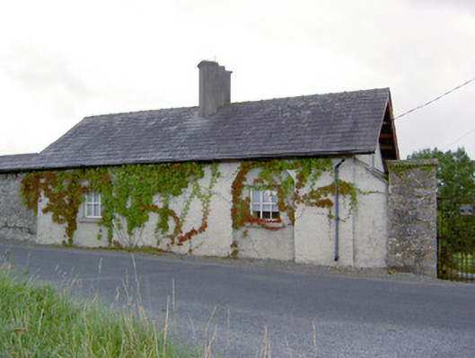
Detached two-bay single-storey former gate lodge/gamekeeper’s house associated with Keel Deer Park (13402728), built c. 1800, having attic storey, gable-fronted porch to the centre of the front elevation (southwest), single-storey lean-to section to northwest elevation and two-bay extension to southeast elevation. Now in use as a private house. Pitched natural slate roof with overhanging bracketed eaves and with central clustered rendered chimneystacks on diagonal-plan. Roughcast rendered walls. Square-headed window openings to northeast elevation, set in recessed round-headed blind arches, having tooled cut limestone sills and replacement timber casement windows. Square-headed window opening to northwest elevation having leaded glass. Square-headed door opening to northwest face of porch having timber battened door. Detached two-storey outbuilding to northwest having pitched corrugated-metal roof with raised rendered verges to gable ends, random rubble limestone walls, square-headed window and door openings with brick voussoirs and timber fittings, and a segmental-headed carriage arch with brick voussoirs and timber double doors. Located to the east boundary of Keel Deer Park (13402728), its northeast elevation forming part of the boundary wall, and to the south of Ballymahon. Newcastle House (13402709) to the northwest. Gateway to the north of house comprising a limestone gate pier (on square-plan) to the south, a modern gate pier to the north, and having wrought-iron gates.
Pihak dan peran
Perancang dan pelaksana belum diringkas dalam tabel ini. Nama dan perannya mungkin disebut dalam uraian sumber; baca sesuai konteksnya.
Atribusi berlaku pada fase yang disebut. Pemesan, perancang, pelaksana, dan pembangun mempunyai peran berbeda.
Riwayat perubahan
Indeks masa menurut inventaris
Rentang sumber dipertahankan untuk penelusuran masa; riwayat asli menjadi dasar bagi ketidakpastian dan fase lain.
Keterangan tanggal: Batas era DATEFROM/DATETO menurut sumber; bukan durasi pekerjaan, tahun pasti, atau survei kondisi.Uraian fisik dalam inventaris sumber
Identitas dan uraian mengikuti rekaman resmi. Pengambilan data tidak dianggap sebagai survei kondisi fisik mutakhir.
Ukuran dan sistem
Istilah bahan dalam uraian mencakup pasangan batu tidak beraturan (rubble), bata (brick), batu tulis (slate), kayu (timber), besi tempa (wrought iron), lapisan roughcast, batu kapur (limestone), lapisan render, kaca (glass). Uraian sumber belum diolah menjadi data ukuran atau spesifikasi teknis. Lingkup komponen dan perubahannya mengikuti uraian asli inventaris.
- Bahan dan sistem
- pasangan batu tidak beraturan (rubble) · Kosakata sumber; komponen, fungsi, dan fase mengikuti uraian asli.Dasar informasi:[1]
- Bahan dan sistem
- bata (brick) · Kosakata sumber; komponen, fungsi, dan fase mengikuti uraian asli.Dasar informasi:[1]
- Bahan dan sistem
- batu tulis (slate) · Kosakata sumber; komponen, fungsi, dan fase mengikuti uraian asli.Dasar informasi:[1]
- Bahan dan sistem
- kayu (timber) · Kosakata sumber; komponen, fungsi, dan fase mengikuti uraian asli.Dasar informasi:[1]
- Bahan dan sistem
- besi tempa (wrought iron) · Kosakata sumber; komponen, fungsi, dan fase mengikuti uraian asli.Dasar informasi:[1]
- Bahan dan sistem
- lapisan roughcast · Kosakata sumber; komponen, fungsi, dan fase mengikuti uraian asli.Dasar informasi:[1]
- Bahan dan sistem
- batu kapur (limestone) · Kosakata sumber; komponen, fungsi, dan fase mengikuti uraian asli.Dasar informasi:[1]
- Bahan dan sistem
- lapisan render · Kosakata sumber; komponen, fungsi, dan fase mengikuti uraian asli.Dasar informasi:[1]
- Bahan dan sistem
- kaca (glass) · Kosakata sumber; komponen, fungsi, dan fase mengikuti uraian asli.Dasar informasi:[1]
Ukuran belum diringkas dalam tabel ini. Baca angka pada uraian sumber bersama definisi, fase, dan lingkupnya.
Dokumentasi dan sumber
Edisi sumber dan hak penggunaan
Copyright Government of Ireland. Data created by National Inventory of Architectural Heritage, Department of Housing, Local Government and Heritage, licensed for re-use under the Creative Commons Attribution 4.0 International licence. Original English Description and Appraisal retained. Indonesian summaries, structured categorisation and selection are adaptations by Arsitektur. No endorsement by the source publisher is implied.
Copyright Government of Ireland. Data created by National Inventory of Architectural Heritage, Department of Housing, Local Government and Heritage, licensed for re-use under the Creative Commons Attribution 4.0 International licence. Original English Description and Appraisal retained. Indonesian summaries, structured categorisation and selection are adaptations by Arsitektur. No endorsement by the source publisher is implied.
Creative Commons Attribution 4.0 ↗
Ringkasan berbahasa Indonesia disusun dari nama, lokasi, kategori, dan istilah arsitektur pada catatan sumber. Teks sumber berbahasa Inggris mengikuti ketentuan penggunaan yang tercantum di atas. Penelaahan ahli independen belum tercatat.
Lingkup identitas: Satu bangunan sesuai nomor inventaris dan uraian pembuka sumber. Bagian yang melekat mengikuti uraian; bangunan terpisah dan kelompok yang tidak jelas disisihkan.
Status sumber: Rekaman inventaris NIAH; pencatatan ini tidak otomatis menyatakan perlindungan hukum RPS · Klasifikasi sumber: Regional. Tanggal penetapan bukan tanggal konstruksi.
Tanggal atau versi data sumber: 2023-08-24.
Survei yang disebut sumber: NIAH Survey of County Longford 2005. Ini tidak menyatakan survei kondisi mutakhir oleh Arsitektur.
Penilaian dan konteks dalam inventaris
Teks dari NIAH Irlandia · bahasa Inggris
Although now altered, this former gate lodge/gamekeeper’s house associated with Keel Deer Park (13402728) retains much of its early character and form. The loss of the original fittings to the majority of the openings fails to detract substantially from its architectural and visual expression. This simple building has a number of interesting features, including the recessed round-headed arches to the northeast that helps lend this elevation a subdued formal architectural character. The clustered diagonally-set chimneystacks are vaguely Tudor in style and create an interesting silhouette. This building and the deer park were originally built to serve Newcastle House (13402709) to the northeast, the seat of the Harman family from c. 1700 and the King-Harman family from c. 1850. It was probably originally laid out by Laurence Parsons-Harman (1749 - 1807) who inherited the estate in 1784 and greatly increased the extent of the Newcastle estate to approximately 31,000 acres by his death in 1807. However, there is a record of a Robert Choppyne of Newcastle House leasing the lands of Keel in 1693 so it is possible that this deer park has its origins at the end of the seventeenth century. It was described c. 1835 as ‘it is a large park, well covered with trees… it is the property of the Countess Dowager of Rosse… ’ (O’Donovan Letters) and was listed as ‘herds, house outbuildings and land’, c. 1860 (Griffith’s Valuation). Its vast scale and largely wooded appearance on early maps (Ordnance Survey first edition six-inch map 1838) suggests that it was used as a hunting reserve by the Harman and later the King-Harman family (and for entertaining local gentry, guests etc.) and its size would have been a considerable status symbol for the owners of Newcastle House. The deer park would also have provided venison for use on the Newcastle estate and, perhaps, to provide income for the estate from the sale of meat etc. This building forms part of a pair of related structures along with the deer park itself (13402728), and part of a wider group of structures associated with Newcastle House.
- Adaptasi inventaris dengan ringkasan berbahasa Indonesia dan uraian asli berizin. Kurasi data dan pemeriksaan sampel tidak menyatakan penelaahan ahli independen untuk setiap bangunan.
- Tanggal akses, survei sumber, penetapan, dan pembangunan mempunyai arti berbeda. Data yang belum jelas dipertahankan tanpa mengisi pihak atau ukuran dengan perkiraan.
Dasar informasi
- National Inventory of Architectural Heritage, Department of Housing, Local Government and Heritage · 13402724 · Deerpark Lodge ↗National Inventory of Architectural Heritage, Department of Housing, Local Government and Heritage · data resmi diakses pada 2026-10-15 · dokumen 2023-08-24
- National Inventory of Architectural Heritage, Department of Housing, Local Government and Heritage · lokasi inventaris 13402724 ↗National Inventory of Architectural Heritage, Department of Housing, Local Government and Heritage · data resmi diakses pada 2026-10-15
Kredit dokumentasi
National Inventory of Architectural Heritage · Department of Housing, Local Government and Heritage · Izin pendidikan atau pribadi NIAH
Lihat sumber dokumentasi ↗
Berkas sumber ditampilkan utuh tanpa penyuntingan; resolusi asli 529 × 398 piksel.
Izin NIAH untuk penggunaan pendidikan atau pribadi dengan kredit sumber. Penggunaan komersial memerlukan persetujuan tertulis NIAH.
Disusun oleh Arsitektur. Penelaahan ahli independen tidak diklaim.
Perubahan isi: 2026-10-17. Tanggal ini tidak menyatakan survei fisik, tanggal dokumen, atau penelaahan independen.