house, Bridge Street · NIAH 40800401
house, Bridge Street · NIAH 40800401 tercatat di Ramelton, DONEGAL, Irlandia sebagai bangunan hunian. Rekaman 40800401 memuat uraian arsitektur dan konteks bangunan. Bahasannya mencakup pasangan batu tidak beraturan (rubble), batu (stone), batu tulis (slate), kayu (timber).
- Jenis objek
- Bangunan
- Fungsi
- bangunan hunian · penelusuran klasifikasi sumber
- Masa tercatat
- Rentang taksiran masa dalam inventaris: 1740–1780
- Kondisi dan status
- Bangunan terdokumentasi dalam inventaris
Identitas dan tapak
Inventaris menempatkan house, Bridge Street · NIAH 40800401 di Ramelton, DONEGAL, Irlandia. Alamat yang dicatat sumber: Bridge Street. Lingkup tapak dan hubungan dengan bangunan lain mengikuti keterangan sumber; titik tidak mewakili batas persil.
- Nama utama
- house, Bridge Street · NIAH 40800401
- Lokasi
- Ramelton, DONEGAL, Irlandia · Bangunan di Irlandia
- Nama lain dalam sumber
- 40800401; NIAH 40800401
- Klasifikasi sumber
- house · nomor 40800401
- Dasar kondisi
- Keterangan mengikuti snapshot sumber 2023-08-24. Tidak tersedia survei kondisi mutakhir oleh Arsitektur; status perlindungan dan rating dibaca sesuai arti pada sumber.
Lihat di Peta Arsitektur ↗
Ruang dan fungsi
Klasifikasi historis sumber menyebut house. Katalog mengelompokkannya sebagai bangunan hunian untuk penelusuran. Klasifikasi ini tidak menyatakan fungsi operasional, akses kunjungan, atau kondisi pada saat ini.
Membaca arsitektur
Uraian fisik asli disajikan dengan nomor rekaman 40800401. Kosakata yang disebut meliputi pasangan batu tidak beraturan (rubble), batu (stone), batu tulis (slate), kayu (timber), besi tempa (wrought iron), atap (roof), jendela (window), jendela geser vertikal (sash). Daftar istilah ini membantu penelusuran. Susunan ruang, hubungan antarkomponen, dan fasenya perlu dibaca dalam uraian asli.
Deskripsi fisik dalam sumber
Teks dari NIAH Irlandia · bahasa Inggris
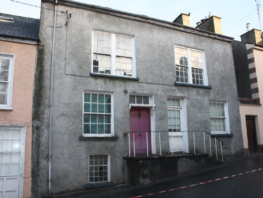
Attached four-bay two-storey over basement level house with attic level, built c. 1760 and altered c. 1900, having three-storey elevation to rear (north). Originally a building in single ownership but now divided into two separate properties. Formerly in use as a Freemasons’ hall\lodge for a period prior to 1811. Building restored by Ramelton Georgian\Heritage Society, c. 1980, and formerly in use as restaurant and concert hall from c. 1986 to c. 1996. Currently out of use. Pitched artificial slate roof with skylight to front (south), projecting rendered eaves courses, clay ridge tiles, and with smooth rendered chimneystacks to the gable ends (east and west). Two dormer openings to the rear (north) having hipped slate roofs over and slate-hung walls to side elevations. Pebbledashed walls to front (south), rear (north) and east sides; cement rendered walls to west elevation. Square-headed window openings to front elevation (south) with smooth rendered reveals, painted sills, and with paired six-over-six pane timber sliding sash windows at first floor level, eight-over-eight pane timber sliding sash windows at ground floor level, and with single window opening to the west end at basement level having eight-over twelve pane casement window. Square-headed window openings to the rear elevation having exposed sash boxes, and with mainly six-over-six pane timber sliding sash windows; round-headed window opening to the rear elevation lighting stairwell (offset to the west side of centre) having twelve-over-twelve pane timber sliding sash window with radial head; round window opening over beneath eaves. Square-headed window openings to dormers having multi-pane timber casement windows. Stone sills to rear. Square-headed door opening to the east side of house to the west having replacement timber door, timber canopy over with decorative brackets and moulded lintel, and with tripartite overlight. Square-headed door opening to the west side of house to the east having replacement glazed timber door, and with tripartite overlight. Doorways reached by flight of rendered steps to rendered platform; wrought-iron handrail and railings. Square-headed doorway to rear (north) having glazed timber door and overlight. Road-fronted to the centre of Ramelton. Enclosed garden to rear (north), on sloping ground, overlooking Leannan River, with rendered flight of steps leading to house’ garden enclosed by modern rubble stone boundary wall.
Pihak dan peran
Perancang dan pelaksana belum diringkas dalam tabel ini. Nama dan perannya mungkin disebut dalam uraian sumber; baca sesuai konteksnya.
Atribusi berlaku pada fase yang disebut. Pemesan, perancang, pelaksana, dan pembangun mempunyai peran berbeda.
Riwayat perubahan
Indeks masa menurut inventaris
Rentang sumber dipertahankan untuk penelusuran masa; riwayat asli menjadi dasar bagi ketidakpastian dan fase lain.
Keterangan tanggal: Batas era DATEFROM/DATETO menurut sumber; bukan durasi pekerjaan, tahun pasti, atau survei kondisi.Uraian fisik dalam inventaris sumber
Identitas dan uraian mengikuti rekaman resmi. Pengambilan data tidak dianggap sebagai survei kondisi fisik mutakhir.
Ukuran dan sistem
Istilah bahan dalam uraian mencakup pasangan batu tidak beraturan (rubble), batu (stone), batu tulis (slate), kayu (timber), besi tempa (wrought iron), lapisan render. Uraian sumber belum diolah menjadi data ukuran atau spesifikasi teknis. Lingkup komponen dan perubahannya mengikuti uraian asli inventaris.
- Bahan dan sistem
- pasangan batu tidak beraturan (rubble) · Kosakata sumber; komponen, fungsi, dan fase mengikuti uraian asli.Dasar informasi:[1]
- Bahan dan sistem
- batu (stone) · Kosakata sumber; komponen, fungsi, dan fase mengikuti uraian asli.Dasar informasi:[1]
- Bahan dan sistem
- batu tulis (slate) · Kosakata sumber; komponen, fungsi, dan fase mengikuti uraian asli.Dasar informasi:[1]
- Bahan dan sistem
- kayu (timber) · Kosakata sumber; komponen, fungsi, dan fase mengikuti uraian asli.Dasar informasi:[1]
- Bahan dan sistem
- besi tempa (wrought iron) · Kosakata sumber; komponen, fungsi, dan fase mengikuti uraian asli.Dasar informasi:[1]
- Bahan dan sistem
- lapisan render · Kosakata sumber; komponen, fungsi, dan fase mengikuti uraian asli.Dasar informasi:[1]
Ukuran belum diringkas dalam tabel ini. Baca angka pada uraian sumber bersama definisi, fase, dan lingkupnya.
Dokumentasi dan sumber
Edisi sumber dan hak penggunaan
Copyright Government of Ireland. Data created by National Inventory of Architectural Heritage, Department of Housing, Local Government and Heritage, licensed for re-use under the Creative Commons Attribution 4.0 International licence. Original English Description and Appraisal retained. Indonesian summaries, structured categorisation and selection are adaptations by Arsitektur. No endorsement by the source publisher is implied.
Copyright Government of Ireland. Data created by National Inventory of Architectural Heritage, Department of Housing, Local Government and Heritage, licensed for re-use under the Creative Commons Attribution 4.0 International licence. Original English Description and Appraisal retained. Indonesian summaries, structured categorisation and selection are adaptations by Arsitektur. No endorsement by the source publisher is implied.
Creative Commons Attribution 4.0 ↗
Ringkasan berbahasa Indonesia disusun dari nama, lokasi, kategori, dan istilah arsitektur pada catatan sumber. Teks sumber berbahasa Inggris mengikuti ketentuan penggunaan yang tercantum di atas. Penelaahan ahli independen belum tercatat.
Lingkup identitas: Satu bangunan sesuai nomor inventaris dan uraian pembuka sumber. Bagian yang melekat mengikuti uraian; bangunan terpisah dan kelompok yang tidak jelas disisihkan.
Status sumber: Rekaman inventaris NIAH; pencatatan ini tidak otomatis menyatakan perlindungan hukum RPS · Klasifikasi sumber: Regional. Tanggal penetapan bukan tanggal konstruksi.
Tanggal atau versi data sumber: 2023-08-24.
Survei yang disebut sumber: NIAH Survey of Donegal 2008 - 2012. Ini tidak menyatakan survei kondisi mutakhir oleh Arsitektur.
Penilaian dan konteks dalam inventaris
Teks dari NIAH Irlandia · bahasa Inggris
This attractive if plain house, probably originally dating to the mid-to-late nineteenth century, retains much of its early form and character despite some later alterations. Only in single ownership, the building was later subdivided to create two dwellings. Its visual appeal is enhanced by the retention of salient fabric and while some of the fittings to the openings have been replaced, the modern replacements are in largely keeping with the original fabric and fail to detract substantially from its integrity. The preservation of a number of early nineteenth-century sash windows to the rear, including one lighting the stair hall surmounted by a radial fanlight, adds to its architectural interest. Although it presents a modest aspect to the road-frontage to the south, the ground slopes away to the rear (north) towards the River Leanne concealing a surprisingly large composition. The wide paired window openings to the front elevation at first floor level are an interesting feature; they may be the result of an earlier function (see below), while there are many examples of such features on contemporary houses in Britain that were the homes of linen weavers to allow for the maximum ingress of natural light (the linen industry was important in the Ramelton area during the eighteenth and nineteenth centuries); a number of modest houses in this part of Ramelton share this feature. This building probably originally dates to the eighteenth century although it occupies the oldest part of Ramelton and may contain earlier fabric. Although probably originally built as a house, this building was apparently also in use as a Masonic Hall (Ramelton old lodge No. 407) for a number of years prior to the establishment of a new lodge (see 40823076) in 1811 to the south-east along Meetinghouse Lane; the wide paired window openings at first floor level might be indicative of this former use as a hall. It was restored by the Ramelton Georgian Society in the 1990s and was in use as a restaurant and hall for a number of years thereafter. There was formerly a large store or warehouse located to the rear adjacent to the waterfront (Ordnance Survey first edition map of 1834), now demolished. This building forms part of an interesting collection of dwellings and former dwellings in Ramelton, and is an integral element of the built heritage of the local area.
- Adaptasi inventaris dengan ringkasan berbahasa Indonesia dan uraian asli berizin. Kurasi data dan pemeriksaan sampel tidak menyatakan penelaahan ahli independen untuk setiap bangunan.
- Nama utama bangunan yang jelas belum tersedia pada bidang nama sumber. Judul katalog menggunakan jenis bangunan dan alamat/tempat beserta nomor inventaris.
- Tanggal akses, survei sumber, penetapan, dan pembangunan mempunyai arti berbeda. Data yang belum jelas dipertahankan tanpa mengisi pihak atau ukuran dengan perkiraan.
Dasar informasi
- National Inventory of Architectural Heritage, Department of Housing, Local Government and Heritage · 40800401 · house, Bridge Street · NIAH 40800401 ↗National Inventory of Architectural Heritage, Department of Housing, Local Government and Heritage · data resmi diakses pada 2026-10-15 · dokumen 2023-08-24
- National Inventory of Architectural Heritage, Department of Housing, Local Government and Heritage · lokasi inventaris 40800401 ↗National Inventory of Architectural Heritage, Department of Housing, Local Government and Heritage · data resmi diakses pada 2026-10-15
Kredit dokumentasi
National Inventory of Architectural Heritage · Department of Housing, Local Government and Heritage · Izin pendidikan atau pribadi NIAH
Lihat sumber dokumentasi ↗
Berkas sumber ditampilkan utuh tanpa penyuntingan; resolusi asli 529 × 398 piksel.
Izin NIAH untuk penggunaan pendidikan atau pribadi dengan kredit sumber. Penggunaan komersial memerlukan persetujuan tertulis NIAH.
Disusun oleh Arsitektur. Penelaahan ahli independen tidak diklaim.
Perubahan isi: 2026-10-17. Tanggal ini tidak menyatakan survei fisik, tanggal dokumen, atau penelaahan independen.